Blizzard Warning For Burleigh, Morton and Surrounding Counties
The Christmas blizzard is becoming a reality and now the forecasters have a better grasp for conditions and tracking of this major weather event.
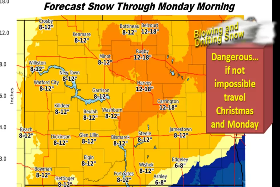
Now is the time to make preparations as this will be a major snow storm and blizzard event. The National Weather Service is confident that this powerful system will impact a majority of the state with heavy snow and very strong winds. This will be a full blown blizzard with widespread snow fall in the amounts of 6 to 12 inches and some areas of 15 or more inches, combined with winds as high as 60 miles per hour.
These conditions will make for nearly impossible travel if totally impossible in some areas. Now is the time to make or change your travel plans for the holiday as this storm can be life threatening.
The counties included in the blizzard warning area include McHenry, McKenzie, Morton, Burleigh, Kidder, Grant, Sioux, Emmons, Logan, Oliver, Mercer and Hettinger.
The Blizzard Warning is in effect from 6 a.m. Sunday through 12 noon Monday. (CST) This storm will cause very strong winds, white out conditions, snow drifts and very dangerous travel if not impossible. The major difference between this blizzard and the blizzard of two weeks ago, this system is a faster moving system, where the previous system lasted for 72 hours.
You are strongly encouraged to stay weather alert with the Severe Weather Action Team (SWAT) and Townsquare Media.
More From 96.5 The Walleye